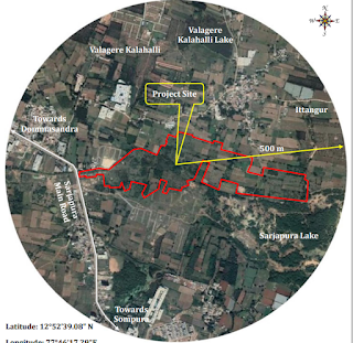
NEW RESIDENTIAL PROJECT SARJAPUR ROAD LAND ENVIRONMENT
The first feature which influence the development of a project is the existing land use
pattern of the neighborhood of the project, whether the proposed development conforms to the
development for that area or not.
The detail study of the land environment will include the following study areas
pattern of the neighborhood of the project, whether the proposed development conforms to the
development for that area or not.
The detail study of the land environment will include the following study areas
- Study of land use pattern, habitation, cropping pattern, forest cover, environmental sensitive places etc, employing remote sensing techniques (if available) and ground truth and also secondary data sources.
- Study about trend of change in land use pattern, if any, with reasons thereof for the last 10 years based on remote sensing techniques data and its extrapolation to future 10 years with and without the project.
PRESTIGE SARJAPUR LAND USE PATTERN
The use of land is determined both by physical factors such as topography, climate, and
soil types as well as human factors such as population density, technological capability, culture &
tradition etc. Land use has a major impact on natural resources including ware, soil, nutrients,
plants and animals.
“Land Use” in the urban planning context means the use to which zones of land are put to.
It could be residential, commercial, industrial, parks and open space, playground, traffic and
transportation etc. The use to which land should be put to must be optional. This can be done
only if the existing land use is estimated.
Existing Land use
The proposed land use designated in the Master Plan - 2031 of Anekal Local Planning
Area for Sarjapura Hobli, Anekal Taluk, is shown in the Fig - 3.
It is observed that the major portion of the proposed project site is located in Residential
Zone, partially Commercial Zone, partially Public & Semi Public Zone. The major portion of the
project is located in the residential zone, only the driveway has been proposed in the small
portion of the commercial zone where the entry and exit to the project to be given and there is a
buffer area in the public and semipublic zone as the nala is adjacent to the public & semipublic
zone. The required conversions will be obtained. The overall land use proposed for the
contained Anekal Local Planning Area as per the Master Plan – 2031 is as enumerated in the
following table.
Related Keywords :
Prestige Smart City Blog -Prestige Group-Sarjapur Main Road-East Bangalore-Real Estate—Sarjapur Road-Apartments In Bangalore-Pre launch Apartments In Sarjapur Main Road-Pre launch Apartments In Sarjapur Road-Pre launch Apartments In East Bangalore-Apartments In East Bangalore-Apartments In Sarjapur Main Road-Pre launch Apartments In Bangalore-Apartments In Sarjapur Road-Prestige Group Apartments In Bangalore-Prestige Smart City Bangalore-Prestige Smart City Sarjapur Main Road-Prestige Smart City Location

Comments